Chandler-Johnson A-19
Howdy,
I'm looking for a map that shows exactly where my family's mineral rights lease is located.
All I got so far is the survey location, called Chandler-Johnson A-19.
I've read it's somewhere South of Lufkin, TX.
Does anyone know how to find that location on GPS or a Google Maps if I drive there?
Much Appreciated,
Lance
Views: 3466
Replies to This Discussion
-
landownerPermalink Reply by Lance Oliver on -
My two brothers and I have a Mineral Lease with Kodiac of close to 70 acres in the survey in question.
-
landownerPermalink Reply by Lance Oliver on -
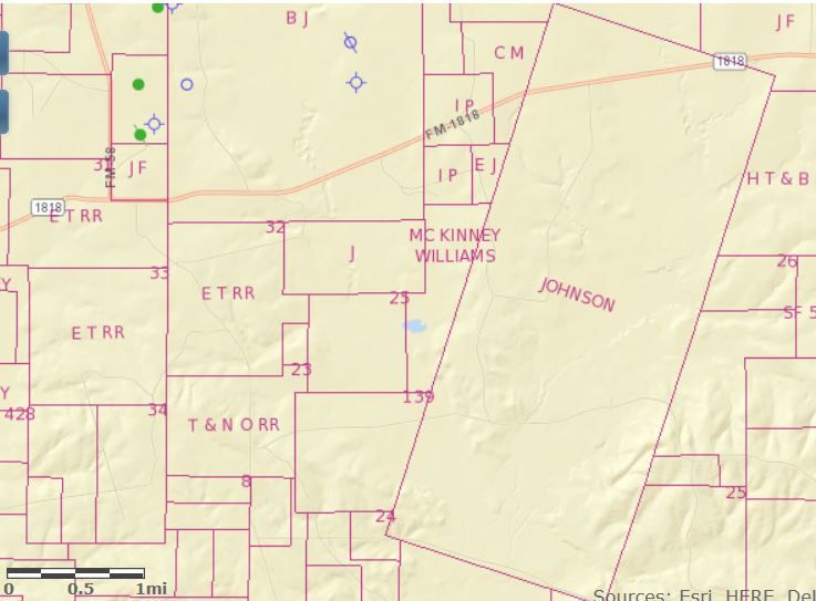
I pulled up the TX RRC GIS site and zoomed in on the area around HW 58 / FM 1818. However, I still can't find A19. If you found it on that map, please tell me where to look.
Thanks!
-
landownerPermalink Reply by Lance Oliver on -
Much appreciated Mike! Thanks alot. I still dont see A-19 but I do see the Johnson designation in association with the survey for our lease. Our family's track looks to be over 2 miles wide by 5 miles long. Wow!
-
landownerPermalink Reply by Lance Oliver on -
I visited the area south of Lufkin this past Sunday. I saw its heavily forested and a portion appears to be very wet bottom land. My brothers and I were pleased to see BBX Operating, L.L.C., who we have our lease with, just announced they will drill their first deep well on the survey called, "Bigfoot".
http://www.gohaynesvilleshale.com/forum/topics/bbx-permits-bigfoot-...
The drilling permit in question is a .pdf attachment on that page.
It states the drill site is RRC distict #06, 9.85 miles SW of Zavalla on the A-19 survey. I'm interested in finding the precise location on Google Earth, so I can pinpoint where to go on my next trip there.
Any help narrowing down the exact location of "Bigfoot" is appreciated.
-
landownerPermalink Reply by Lance Oliver on -
Great!
Looks like I was lucky enough to have gotten to the Renfro Cemetery, only a few miles away from the pending drill site.
Thank You!
-
-
landownerPermalink Reply by Lance Oliver on -

-
-
landownerPermalink Reply by Lance Oliver on -
BBX has the equipment needed to get at the shale there, which is something the other companies weren't able to do. I'm planning to go back there for photo ops as soon as the drilling equipment is positioned. We wish them the best of fortune!
-
-
landownerPermalink Reply by Lance Oliver on -
I would like to see some sort of geological overlays for the Chandler Johnson A-19 survey, so what is considered to be there can be better understood.
-
-
landownerPermalink Reply by Lance Oliver on -
-
landownerPermalink Reply by Lance Oliver on -

-
landownerPermalink Reply by Lance Oliver on -
I found a site that mentions several types of plays, such as Eagle Ford and Eaglebine...
http://eaglefordshale.com/geology/
So, my question now is...
Is the Chandler Johnson A-19 survey over Haynesville Shale or some other formation(s)?
Visit the Forum and click "Follow" after the last discussion.
Top Content
Groups
-
North LA Cotton Valley C…
68 members
-
Shelby County, TX
478 members
-
Nacogdoches County
194 members
-
SMACKOVER LITHIUM GROUP …
11 members
-
Natchitoches Parish
405 members
-
WESTERN HAYNESVILLE
18 members
-
Bienville Parish, LA
250 members
-
Sabine Parish, LA
457 members
-
SMACKOVER LITHIUM GROUP …
11 members
-
San Augustine, TX
388 members
Blog Posts
Tuscaloosa Trend Sits On Top Of Poorest Neighbourhood For Decades - Yet No Royalties Ever Paid To The Community -- Why??
Posted by Char on May 29, 2025 at 14:42 — 4 Comments
© 2026 Created by Keith Mauck (Site Publisher).
Powered by
![]()